|
| During 1996, members of Student
Speleologic and Alpinistic Club explored 900 m of new galleries
and resurveyed Cerjanska pecina (pecina = cave). The length
of the cave was increased to 5190 m, and the new denivelation is
173 m. (The current length of the cave is 6.025
m - see the updates of the recent
explorations). Explored for the first time in 1976 by SOB,
the cave was once the longest in Serbia with the surveyed length
of 4240 m.
There were plans for its touristic
exploitation during the seventies. Therefore, the relatively
narrow entrance was widened by blasting, and low crawls at the
entrant part were deepened by digging. However, this active
stream cave was never put into speleotouristic use. The next
spring, the stream washed away wooden beams brought inside to
serve as bridges over deep pools, and new river deposits turned
the entrance part again into a low and wet crawl. Believed to be
thoroughly explored, the cave remained mostly unvisited untlil
the autumn of 1995, when members of ASAK visited its far parts,
finding a continuation of the main gallery. In July 1996, the
cave was resurveyed, including the majority of the new
galleries.
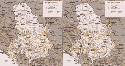
Cerjanska pecina is located in the village of
Cerje, near Nis in southeastern Serbia (250 km from Belgrade).
The entrance to the cave, at 515 m a.s.l. is a swallow hole of a
small stream named Provalija, the resurgence of which is
Kravljansko vrelo (vrelo = spring), 2800 m northwest, at 310 m
a.s.l. A tracing experiment performed in the seventies proved
the connecton of the swallow hole and the spring. At that time,
an unsuccessful diving attempt at the spring was stopped because
of equipment troubles at the depth of 15 m. No diving attempts
were done ever since to connect the Kravljansko vrelo spring and
Cerjanska pecina. According to the result of the recent survey,
the spring is located 400 m from the sumps which end the cave,
and 34 m below them.
On the hill slopes above the spring, a 123 m
deep pit "Jama iznad Kravljanskog vrela" is located at
the altitude of 450 m. On 1996 New Year's eve the pit was
resurveyed and its position corrected (hopefully). A strong air
current blows from the boulder choke at the bottom of the pit
indicating the presence of a voluminous gallery - most probably
connected with Cerjanska pecina. The previous researchers'
calculations showed that the pit was located exactly above the
Salomna dvorana (Collapse hall), the terminus of the former
survey. It was believed that the boulder choke at the bottom of
the pit correspond to the decametric boulders which make the
ceiling and the walls of Collapse hall. However, the new survey
showed that the pit is located 350 m east from the closest
galleries of Cerjanska pecina, and that the bottom of the pit is
close to the level of Kravljansko vrelo spring, below
the sumps at the current terminus of the cave Cerjanska pecina. |

Click
for a large map of Serbia and Montenegro with the cave location
(150 k)

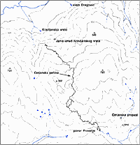
Click
for a large map of the cave
surroundings (19 k), with the locations of
adjacent caves and the overview
of their hydrologic links.

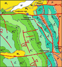
Click
for the geologic survey (40 k)
of the area with the legend |
The cave Cerjanska pecina is characterized by small
dimensions of its entrance part, and big dimensions of its main gallery
- mostly by the height which exceeds 20 m. It is evident that the
present entrance parts have no genetical links with the main gallery. A
fossil gallery of great dimensions, ending in boulder,discovered just
beyond the crawl in the entrance part, might be a connection with old
entrances, now buried below the eroded sides of the amphitheatre which
comprises the swallow hole of Provalija stream.
 Cerjanska
pecina is a wet cave. Even in summer, when the stream bed is dry, the
pools in the crawl are full of water. Further on, a stream flows through
the main gallery, to the sump at the 3rd km. Except the Visoki kanal
fossil gallery, which is really dry, the rest of the cave had no active
flow (at the time of our explorations), but numerous deep pools made the
progress very difficult. Since wetsuit caving is not a common practice
in Serbia, crawling through the puddles near the entrance and stepping
through the pools was usual and clearly unpleasant. The part of the cave
between the 3rd km sump and the Collapse hall (named "Moon
gallery") is particularly depressing. The walls in this part of the
cave are formed in dark, almost black limestone, which erodes in very
sharp shapes, and the floor is covered with deep whirlpools full of
water. To ease the survey of the far end of the cave, a small bivouac
was established near Collapse hall. Cerjanska
pecina is a wet cave. Even in summer, when the stream bed is dry, the
pools in the crawl are full of water. Further on, a stream flows through
the main gallery, to the sump at the 3rd km. Except the Visoki kanal
fossil gallery, which is really dry, the rest of the cave had no active
flow (at the time of our explorations), but numerous deep pools made the
progress very difficult. Since wetsuit caving is not a common practice
in Serbia, crawling through the puddles near the entrance and stepping
through the pools was usual and clearly unpleasant. The part of the cave
between the 3rd km sump and the Collapse hall (named "Moon
gallery") is particularly depressing. The walls in this part of the
cave are formed in dark, almost black limestone, which erodes in very
sharp shapes, and the floor is covered with deep whirlpools full of
water. To ease the survey of the far end of the cave, a small bivouac
was established near Collapse hall.
Climbing to upper portions of almost all the
galleries, even the remote ones, revealed allogenic pebble and rounded
boulder left in the niches at all heights. It is clear that the cave had
been completely filled by allogenic material which was removed later.
Looking at the present topography, it is hard to picture the stream
capable of such act.
Ceilings of some galleries are composed of a strange
mass, looking like decomposing limestone. The microscopic analyses of
the samples showed that the limestone was once altered by hydrothermal
waters. There are few thermal springs at the bottom of the hill 5 km
west from the cave. The exact nature and role of thermal waters in the
genesis of Cerjanska pecina awaits to be clarified in future
explorations.
There are lot of places in the cave to search for new leads, mostly
in the area beyond Collapse hall, and in the high parts of the main
gallery. Some difficult leads await to be pushed: the diving connection
between the sumps at the end of the cave, and the Kravljansko vrelo
spring, and the digging at the bottom of Jama iznad Kravljanskog vrela
which could provide an easier access to the far parts of the cave.
UPDATES
September 1998: current length is
5715 m
After the 96-hours bivouaque in August 1998, and another exploration
in September, the bypass of the sumps at the end of the cave has been
discovered. The terminal part of the cave has been resurveyed, as well
as new galleries, bringing up the new length of 5715 meters. The new
gallery, wet and wide and some 300 m away from Kravlje spring, awaits to
be explored and surveyed.
Diving attempt of Kravljansko
vrelo spring in September 1999
In September 1999, speleo divers from SOB
dived at Kravljansko vrelo spring. A sand and mud blockage at 15 meters
stopped further progress. New diving attpempts are planned after the
period of high waters (in spring), with the hope that the blockage will
be washed away.
October 1999: current
length is 6.025 m, and the denivelation is 176 m
During September and October 1999, ASAK made two bivouacs in
Cerjanska pecina. The passages leading to the gallery at the end of the
cave (named "via Kravlje"), were widened. Unfortunately, it
showed up that "via Kravlje" ends soon in sumps on both ends.
The downstream sump is only 200 meters away from the Kravljansko vrelo
spring. Further explorations in this direction are possible for cave
divers only. New galleries in this part of the cave have been surveyed,
bringing the total length to 6.025 meters, and the denivelation to 176
m.
|
|


